Plate Techtonics
The theory of Plate Tectonics revolves around the idea hat there are these plates that move around in different directions and speeds (from 2 cm - 10 cm per year). The Earth is mainly broken up to 7 main pieces: Pacific, South American, North American, African, Australian, Antarctic, and Eurasian Plates; other smaller plates exist such as: Arabian, Nazca, and Philippines Plates.
Magnetic Stripping
This is part of Plate tectonics as it explains why looking ate the mid ocean ridge, the solidified lava is rich in iron an point toward north (like any magnet), but there are these trips of land that points in the opposite direction of north. With this data it show that at one point the poles reversed during earth's lifetime (this process called polar shifting or polar reversal happen over the period of hundred of thousand of years).

Transform
Plates sliding past each other is called transform. There aren't any really special features like shown on convergent and divergent boundaries, but the most notable thing shown is a valley that is produced after the transformation. While transforming it can that lead into serious earthquakes.
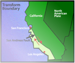
A popular transformation would be the San Andreas Fault, which causes earthquakes causing a lot of damage. Every time it does this this part of California will slowly move upward north (meaning Los Angeles will get closer to San Francisco)
Divergent
Where two plates move away from each other is called divergent. Typically when two plate are moving away from each other, a fault (also kwon as rifts) in created which leads into the asthenosphere, which magma rises to fill in the gap causing earthquakes and eruptions, but also creating new crust along the boundaries of the plates and usually the rifts about 30 - 50 kilometers wide.
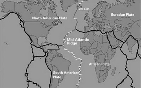
A good example of divergent would be the mid-atlantic ridge where (more than two) plates are diverging causing a long trench in the Atlantic ocean. This is called Seafloor spreading, another vital part of the theory on Plate Tectonics
Seafloor Spreading
At the Mid Atlantic Ridge two main plate are diverging on each other, South American and the African Plates are causing a giant valley under water. As this happens magma (liquid rock that hasn't touched surface ground) is flowing out of the cracks and soon this material is quickly solidified.
If you look at the image above, the two black dots would represent were samples of rocks were taken, through carbon dating the rocks closer to rige are younger than the one far away from the ridge concluding that new land is being formed and that the Atlantic is spreading or is it?
Seafloor Spreading
Seafloor stretching, ever heard about it? If no then your okay, stretching is exactly how it sounds, the rock stretches causing the seafloor to expand.
Convergent
When two plates meet with each other is called convergent. One of the plates are moved while the other slide on top of it causing trenches to form. This causes earthquakes to form around the plates and as the plate moves toward the mantle, some of the rock melt and that molten rock rises causing more earthquakes and volcanic eruptions. As these plate collide land is made, so mountains and volcanoes are formed .

An example of convergent would be the Nazca Plate going in to the South American Plate causing a trench called the "Chilean Trench"
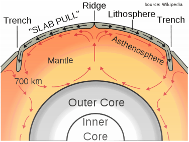
Convection Currents
In the mantle, in the anthenosphere there is a currents going around called convection currents. These currents work kinda like boiling water in a pot, the heated magma from the Earth's core make it go up and once it cools it goes back down to get re-heated (hot rises, cold goes down). The currents continually doing this moves the plates, but this process takes years to really see its effect.
Pangaea

Pangaea is a super continent that existed millions of years ago, all the continents where connected at this stage. Evidence of this would be fossils found on the edges of continents where found on other edges, fossils where in weird climates that weren't suppose to be their and geographically some continents seem to fit into each other (South America seems to fit into Africa).
Resources
- "Earth Floor: Plate Tectonics." Earth Floor: Plate Tectonics. N.p., n.d. Web. 12 Nov. 2013."The Blue Marble." Wikipedia. Wikimedia Foundation, 11 Nov. 2013. Web. 12 Nov. 2013.
- "Plate Tectonics Map - Plate Boundary Map." Plate Tectonics Map. N.p., n.d. Web. 12 Nov. 2013.
- "Natural Hazards | Earthquakes." Natural Hazards | Earthquakes. N.p., n.d. Web. 12 Nov. 2013.
- "Sea-Floor Spreading - PowerPoint." Docstoc.com. N.p., n.d. Web. 12 Nov. 2013.
- "Home." Home. N.p., n.d. Web. 12 Nov. 2013.
- "Nazca Plate." Wikipedia. Wikimedia Foundation, 11 Aug. 2013. Web. 12 Nov. 2013.
- "The Dynamic Earth @ National Museum of Natural History." The Dynamic Earth @ National Museum of Natural History. N.p., n.d. Web. 12 Nov. 2013.
- "First Year 11 Homework of the Year – Convection Currents." Geogteachers Blog. N.p., n.d. Web. 12 Nov. 2013.
- "Dispatches from Pangaea." Dispatches from Pangaea. N.p., n.d. Web. 12 Nov. 2013.
